
ፋይል:Philippines relief location map (Palawan).svg

Size of this PNG preview of this SVG file: 377 × 377 ፒክስላት. ካልኦት ንጹርነታት፦ 240 × 240 ፒክስላት | 480 × 480 ፒክስላት | 768 × 768 ፒክስላት | 1,024 × 1,024 ፒክስላት | 2,048 × 2,048 ፒክስላት።
ናይ መጀመርታ ፋይል (ፋይል SVG፣ ብሽም 377 × 377 ፒክስላት፣ መጠን ፋይል፦ 2.21 መ.ባ.)
.svg)
መጠቓለሊ
| መግለጺ |
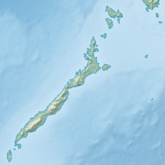
English: Physical location map of the Philippines (Palawan)
Equirectangular projection based on the parallel of 10°43' N
|
| ዕለት | |
| ምንጪ | File:Philippines location map (square).svg |
| ደራሲ | User:Hellerick |
| Other versions |
This file was derived from: Philippines relief location map (square).svg: .svg) |
.svg)
ፍቓድ
This file is licensed under the Creative Commons Attribution-Share Alike 3.0 Unported license.
- You are free:
- to share – to copy, distribute and transmit the work
- to remix – to adapt the work
- Under the following conditions:
- ኣፍልጦ – You must give appropriate credit, provide a link to the license, and indicate if changes were made. You may do so in any reasonable manner, but not in any way that suggests the licensor endorses you or your use.
- share alike – If you remix, transform, or build upon the material, you must distribute your contributions under the same or compatible license as the original.
ታሪኽ ፋይል
Click on a date/time to view the file as it appeared at that time.
| ዕለትን ሰዓትን | ድንኪ | ዓቐናት | ተጠቃሚ | ርእይቶ | |
|---|---|---|---|---|---|
| እዋናዊ | 17:23, 26 ጥቅምቲ 2017 | | 377 × 377 (2.21 መ.ባ.) | Mliu92 | User created page with UploadWizard |
ኣጠቓቕማ ፋይል
ነዚ ፋይል ዝጥቀሙ ገጻት የለዉን።
ዓለማዊ ኣጠቓቕማ ፋይል
The following other wikis use this file:
- ኣጠቓቕማ ኣብ ban.wikipedia.org
- ኣጠቓቕማ ኣብ bcl.wikipedia.org
- ኣጠቓቕማ ኣብ en.wikipedia.org
- Busuanga Island
- Tubbataha Reef
- Calamian Islands
- Puerto Princesa Subterranean River National Park
- Mindoro Strait
- Balabac Island
- Mangarin Bay
- Mount Mantalingajan
- Honda Bay
- Calauit Island
- Rasa Island
- Malampaya Sound
- Delian Island
- Module:Location map/data/Palawan
- Module:Location map/data/Palawan/doc
- Bacungan River
- ኣጠቓቕማ ኣብ fa.wikipedia.org
- ኣጠቓቕማ ኣብ fr.wikipedia.org
- ኣጠቓቕማ ኣብ id.wikipedia.org
- ኣጠቓቕማ ኣብ ilo.wikipedia.org
- ኣጠቓቕማ ኣብ lv.wikipedia.org
- ኣጠቓቕማ ኣብ ml.wikipedia.org
- ኣጠቓቕማ ኣብ si.wikipedia.org
- ኣጠቓቕማ ኣብ uz.wikipedia.org
.svg)