ሞደል:ካርታ ቦታ ኤርትራ
Appearance
[]
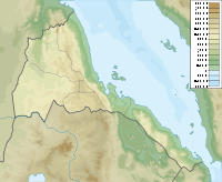
This template only defines the maps to be used and the coordinates of their geographical limits when ኤርትራ is placed in the first parameter without a name of the template {{ካርታ ቦታ}} ({{ካርታ ቦታ|ኤርትራ|<other parameters>}}).
{{G}}.
|
||||||||||||||||||||||||||||
ኣማራጽያዊ ካርታታት
The following maps are compatible with this template. To change the map that appears by default to one of this list, use the ዓይነት parameter adding the corresponding type.
To put any other compatible map that does not appear in this list, use the ኣማራጽያዊ_ካርታ parameter adding the name of the file.
| መግለጺ | ስም ፋይል | ዓይነት | ካርታ |
|---|---|---|---|
| ኣካላዊ ካርታ | Eritrea physical map.svg
|
ቅርጻ_መሬት
|
 |
This content has been generated automatically from the template data.


